
On July 7th, 2005, a series of 4 bomb explosions ripped through London, leaving 54 dead and over 700 injured (BBC, 2005). With much of the world left stunned and grasping for more information, local amateur media producers were pivotal in rapidly providing an image of the situation to the outside world. Within minutes of the blasts images and videos taken by thousands of ordinary citizens -- many of them already carrying digital camera phones -- were uploaded to the B.B.C. and featured on the main website, then syndicated to numerous mainstream news sources worldwide (Owen, 2005). Interestingly, one of the quickest news sources to respond to the bombings was not a commercial news organization, but rather a collation of volunteer reporters contributing to a website known as Wikinews. Through this site, what began by one user living near London's Liverpool Street Station posting a 5 sentence report on the event quickly expanded into a comprehensive view of all the various events taking place as numerous other citizen reporters directly contributed hundreds of additions and revisions to the article.
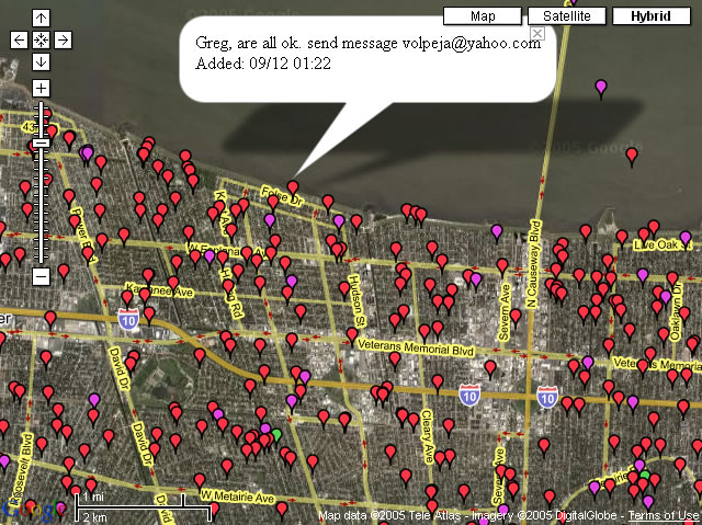
On August 29th, 2005, hurricane Katrina tore apart the levee that protected New Orleans from Lake Pontchartrain and the Mississippi River. This time, not only was the ability of ordinary citizens to share self-produced media and information pivotal in shaping the view of the situation for the outside world (thereby bringing in more relief funds), but also this ability allowed for those affected by the disaster to effectively assist one another. After Jonathan Mendez's parents evacuated from Louisiana to his home in Austin, Texas, he was eager to find out if the floods had destroyed their house in Louisiana. Unfortunately for him, media coverage of the event was focused exclusively on the most devastated parts of New Orleans with little information about the neighborhood his parents house was in. With some help from his co-worker, within a matter of hours they were able to modify the popular "google maps" web service in order to allow users to overlay any information they had about the devastation directly onto a satellite map of New Orleans. Shortly after making their modification publically available, over 14,000 submissions covered their map. This allowed victims scattered throughout the United States to find information about any specific location -- including verifying that the Mendez's house was still intact (Singel, 2005).
(Excepted from the ProjectNML Whitepaper)